Open ground south of the railway

Uploader's Comments
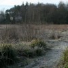
An area of open ground between a railway line to the north, Robslee Drive to the east, Thornliebank Resource Centre and houses to the south, and Eastwood New Cemetery (amongst the trees) to the west. The Auldhouse Burn cuts across the middle.
Uploaded to Geograph by Richard Sutcliffe on 5 January 2017