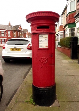
Waterloo Park, Sefton

« Gazetteer Entry
Upload Photo

Waterloo Park, Sefton

  • Built-Up Area: Crosby
  • Parish/Community: Sefton, unparished area
  • Unitary Authority: Sefton
  • Region: North West
  • Category: Populated Place
  • Type: Other Settlement
  • Latitude/Longitude: 53°28'43"N 3°1'6"W
  • Eastings/Northings: 332500, 398500
  • OS Grid: SJ325985
  • Mapcode Local: GBR 7XC6.9N
  • Mapcode Global: WH86T.LTTD

Location and coordinates are for the approximate centre of Waterloo Park within this administrative area. Geographic features and populated places may cross administrative borders.

BritishPlaceNames.uk is a Good Stuff website.