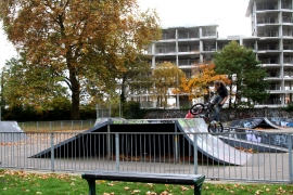
Wandle Park, Croydon

« Gazetteer Entry
Upload Photo

Wandle Park, Croydon

Other current and historical names

  • Waddon
  • Built-Up Area: Croydon
  • Parish/Community: Croydon, unparished area
  • Unitary Authority: Croydon
  • Region: London
  • Category: Populated Place
  • Type: Other Settlement
  • Latitude/Longitude: 51°22'24"N 0°6'43"W
  • Eastings/Northings: 531500, 165500
  • OS Grid: TQ315655
  • Mapcode Local: GBR GX.6DF
  • Mapcode Global: VHGRL.0RL2

Location and coordinates are for the approximate centre of Wandle Park within this administrative area. Geographic features and populated places may cross administrative borders.

BritishPlaceNames.uk is a Good Stuff website.