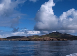
Uineasan, Na h-Eileanan Siar

« Gazetteer Entry
Upload Photo

Uineasan, Na h-Eileanan Siar

  • Unitary Authority: Na h-Eileanan Siar
  • Region: Scotland
  • Category: Water Feature
  • Type: Island
  • Latitude/Longitude: 56°55'52"N 7°29'2"W
  • Eastings/Northings: 66542, 795610
  • OS Grid: NL665956
  • Mapcode Local: GBR 7BXD.GW0
  • Mapcode Global: WGV5F.01GS

Location and coordinates are for the approximate centre of Uineasan within this administrative area. Geographic features and populated places may cross administrative borders.

BritishPlaceNames.uk is a Good Stuff website.