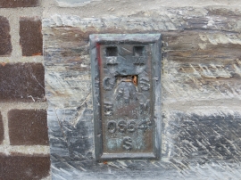
Noyadd Wilym, Ceredigion

« Gazetteer Entry
Upload Photo

Noyadd Wilym, Ceredigion

  • Built-Up Area: Llechryd
  • Parish/Community: Llangoedmor
  • Unitary Authority: Ceredigion
  • Region: Wales
  • Category: Populated Place
  • Type: Other Settlement
  • Latitude/Longitude: 52°4'10"N 4°37'13"W
  • Eastings/Northings: 220500, 244500
  • OS Grid: SN205445
  • Mapcode Local: GBR D1.CNMP
  • Mapcode Global: VH2MW.V7SP

Location and coordinates are for the approximate centre of Noyadd Wilym within this administrative area. Geographic features and populated places may cross administrative borders.

BritishPlaceNames.uk is a Good Stuff website.