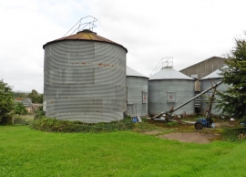
Newton St Cyres, Devon

« Gazetteer Entry
Upload Photo

Newton St Cyres, Devon

  • Parish/Community: Newton St. Cyres
  • District/Borough: Mid Devon
  • County: Devon
  • Region: South West
  • Category: Populated Place
  • Type: Other Settlement
  • Latitude/Longitude: 50°46'30"N 3°35'48"W
  • Eastings/Northings: 287500, 98500
  • OS Grid: SX875985
  • Mapcode Local: GBR QQ.PKHZ
  • Mapcode Global: FRA 37C1.6KB

Location and coordinates are for the approximate centre of Newton St Cyres within this administrative area. Geographic features and populated places may cross administrative borders.

BritishPlaceNames.uk is a Good Stuff website.