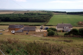
Long Parks Withy Bed, Dorset

« Gazetteer Entry
Upload Photo

Long Parks Withy Bed, Dorset

  • Parish/Community: Abbotsbury
  • District/Borough: West Dorset
  • County: Dorset
  • Region: South West
  • Category: Landcover
  • Type: Forest or Wood
  • Latitude/Longitude: 50°39'44"N 2°34'57"W
  • Eastings/Northings: 358925, 84904
  • OS Grid: SY589849
  • Mapcode Local: GBR PT.SYCH
  • Mapcode Global: FRA 57GB.CNV

Location and coordinates are for the approximate centre of Long Parks Withy Bed within this administrative area. Geographic features and populated places may cross administrative borders.

BritishPlaceNames.uk is a Good Stuff website.