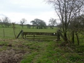
Kirton Wood, Nottinghamshire

« Gazetteer Entry
Upload Photo

Kirton Wood, Nottinghamshire

  • Parish/Community: Egmanton
  • District/Borough: Newark and Sherwood
  • County: Nottinghamshire
  • Region: East Midlands
  • Category: Landcover
  • Type: Forest or Wood
  • Latitude/Longitude: 53°12'27"N 0°56'34"W
  • Eastings/Northings: 470706, 368359
  • OS Grid: SK707683
  • Mapcode Local: GBR BHD.VWV
  • Mapcode Global: WHFGV.HM8V

Location and coordinates are for the approximate centre of Kirton Wood within this administrative area. Geographic features and populated places may cross administrative borders.

BritishPlaceNames.uk is a Good Stuff website.