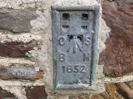
Brook Copse, Devon

« Gazetteer Entry
Upload Photo

Brook Copse, Devon

  • Parish/Community: Atherington
  • District/Borough: North Devon
  • County: Devon
  • Region: South West
  • Category: Landcover
  • Type: Forest or Wood
  • Latitude/Longitude: 50°59'15"N 4°1'28"W
  • Eastings/Northings: 257989, 122864
  • OS Grid: SS579228
  • Mapcode Local: GBR KS.L270
  • Mapcode Global: FRA 26GH.MVW

Location and coordinates are for the approximate centre of Brook Copse within this administrative area. Geographic features and populated places may cross administrative borders.

BritishPlaceNames.uk is a Good Stuff website.