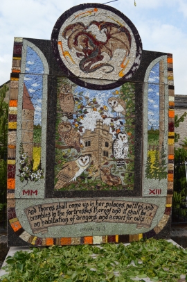
Youlgreave, Derbyshire

« Gazetteer Entry
Upload Photo

Youlgreave, Derbyshire

Other current and historical names

  • Bradford
  • Built-Up Area: Youlgreave
  • Parish/Community: Youlgreave
  • District/Borough: Derbyshire Dales
  • County: Derbyshire
  • Region: East Midlands
  • Category: Populated Place
  • Type: Village
  • Latitude/Longitude: 53°10'30"N 1°41'11"W
  • Eastings/Northings: 421057, 364280
  • OS Grid: SK210642
  • Mapcode Local: GBR 585.SKQ
  • Mapcode Global: WHCDF.2G65

Location and coordinates are for the approximate centre of Youlgreave within this administrative area. Geographic features and populated places may cross administrative borders.

BritishPlaceNames.uk is a Good Stuff website.