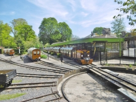
Trimby's White Marshes Plantation, East Dorset

« Gazetteer Entry
Upload Photo

Trimby's White Marshes Plantation, East Dorset

  • Parish/Community: Horningsham
  • Unitary Authority: East Dorset
  • Region: South West
  • Category: Landcover
  • Type: Forest or Wood
  • Latitude/Longitude: 51°11'9"N 2°17'22"W
  • Eastings/Northings: 379862, 143030
  • OS Grid: ST798430
  • Mapcode Local: GBR 0SX.HZN
  • Mapcode Global: VH97M.8GG2

Location and coordinates are for the approximate centre of Trimby's White Marshes Plantation within this administrative area. Geographic features and populated places may cross administrative borders.

BritishPlaceNames.uk is a Good Stuff website.