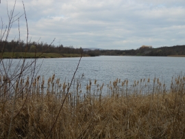
Treeton Dyke, Rotherham

« Gazetteer Entry
Upload Photo

Treeton Dyke, Rotherham

  • Built-Up Area: Fence
  • Parish/Community: Aston cum Aughton
  • Unitary Authority: Rotherham
  • Region: Yorkshire and The Humber
  • Category: Water Feature
  • Type: Other Water Feature
  • Latitude/Longitude: 53°22'24"N 1°20'51"W
  • Eastings/Northings: 443500, 386500
  • OS Grid: SK435865
  • Mapcode Local: GBR MY1F.1D
  • Mapcode Global: WHDDR.8GJL

Location and coordinates are for the approximate centre of Treeton Dyke within this administrative area. Geographic features and populated places may cross administrative borders.

BritishPlaceNames.uk is a Good Stuff website.