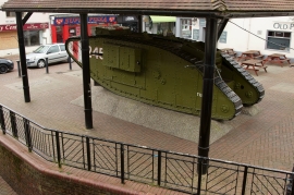
St George's Square, Kent

« Gazetteer Entry
Upload Photo

St George's Square, Kent

  • Built-Up Area: Ashford (Ashford)
  • Parish/Community: Ashford, unparished area
  • District/Borough: Ashford
  • County: Kent
  • Region: South East
  • Category: Populated Place
  • Type: Other Settlement
  • Latitude/Longitude: 51°9'0"N 0°52'13"E
  • Eastings/Northings: 600856, 142916
  • OS Grid: TR008429
  • Mapcode Local: GBR RWP.YQ5
  • Mapcode Global: VHKKN.1CK2

Location and coordinates are for the approximate centre of St George's Square within this administrative area. Geographic features and populated places may cross administrative borders.

BritishPlaceNames.uk is a Good Stuff website.