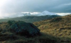
Sròn Na Maoile, Perth and Kinross

« Gazetteer Entry
Upload Photo

Sròn Na Maoile, Perth and Kinross

  • Unitary Authority: Perth and Kinross
  • Region: Scotland
  • Category: Geographic Feature
  • Type: Hill or Mountain
  • Latitude/Longitude: 56°19'56"N 4°7'9"W
  • Eastings/Northings: 269061, 717562
  • OS Grid: NN690175
  • Mapcode Local: GBR 14.54HD
  • Mapcode Global: WH4N4.P3KF

Location and coordinates are for the approximate centre of Sròn Na Maoile within this administrative area. Geographic features and populated places may cross administrative borders.

BritishPlaceNames.uk is a Good Stuff website.