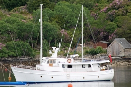
Sgeir Bhuidhe, Highland

« Gazetteer Entry
Upload Photo

Sgeir Bhuidhe, Highland

  • Unitary Authority: Highland
  • Region: Scotland
  • Category: Geographic Feature
  • Type: Other Coastal Landform
  • Latitude/Longitude: 57°20'24"N 5°38'17"W
  • Eastings/Northings: 181164, 833599
  • OS Grid: NG811335
  • Mapcode Local: GBR D9GB.25W
  • Mapcode Global: WH09V.CRDS

Location and coordinates are for the approximate centre of Sgeir Bhuidhe within this administrative area. Geographic features and populated places may cross administrative borders.

BritishPlaceNames.uk is a Good Stuff website.