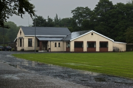
Nook, Lancashire

« Gazetteer Entry
Upload Photo

Nook, Lancashire

  • Built-Up Area: Catterall
  • Parish/Community: Kirkland
  • District/Borough: Wyre
  • County: Lancashire
  • Region: North West
  • Category: Populated Place
  • Type: Hamlet
  • Latitude/Longitude: 53°52'55"N 2°46'48"W
  • Eastings/Northings: 348817, 443149
  • OS Grid: SD488431
  • Mapcode Local: GBR 9R0K.X4
  • Mapcode Global: WH850.8PDC

Location and coordinates are for the approximate centre of Nook within this administrative area. Geographic features and populated places may cross administrative borders.

BritishPlaceNames.uk is a Good Stuff website.